The Burroughs, 07/19/09

After “losing” the first weekend in July to my grandmother’s 80th birthday party and the second to a Saturday spent soaking at Breitenbush Hot Springs, we were well overdue for a hike. Sunday was the only day available to us, so we settled on a dayhike at Mt. Rainier National Park.  I’d seen some stunning photographs taken from the Burroughs trail near Sunrise, and yearned for some in-your-face views of The Mountain—on prior trips to Mt. Rainier National Park (Spray Park, Summerland) the eponymous mountain remained frustratingly hidden in cloudcover.  If the weather forecast was to be believed, this day would be different.  It was.

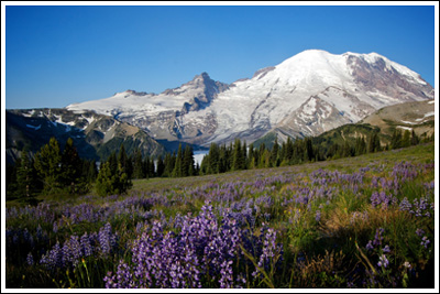
Mt. Rainier and wildflowers from just above Sunrise.

Mt. Rainier and wildflowers from just above Sunrise.

On top of our hike starting at the always-busy Sunrise Visitor Center, we learned during the week that it was Get Into Your National Park Free Day, or some such thing.  So I set my alarm early, had no trouble getting Nicole out of bed, and we were on the road at 04:40.  I love early starts, but even as we cruised through Enumclaw and the tip of The Mountain lit up, I wished we’d started even earlier.  At 06:40, just two hours later, we pulled into Sunrise with our pick of the parking lot.  Ten minutes later, we were on wide empty trails through lupine with outstanding views of Mt. Rainier.  Of course, the views of Mt. Rainier are outstanding from the parking lot.

hikers_50

Read more of this post

Navaho Peak, 06/28/09

Somehow, Nicole and I had yet to truly reach a summit. It’s probably because we’d never picked a hike with the summit of a mountain as our destination. On Mt. Aix, we came close, only to be turned back by fear and thunderclouds. At Marmot Pass earlier this year, summiting Buckhorn Mtn. had been a thought until full backpacks and bum knees made us think otherwise. So reaching a summit was overdue, and Nicole in particular really wanted to accomplish that goal.

Mt. Stuart and The Enchantments Range from Navaho Peak.

Mt. Stuart and The Enchantments Range from Navaho Peak.

Cousin Bobby, who accompanied us on our hike to Goat Lake two weekends ago and didn’t break a sweat the entire time, wanted to go out again. We wanted to take him somewhere impressive, as we only have a few more free weekends until his internship ends. We also wanted to make him sweat.

Our friend David, who just returned from teaching English in Mexico for ~1.75 years and is staying with us at the moment, insisted that he had boundless energy and didn’t want to be left behind. He may have been exaggerating, and he might be regretting his decision at this very moment.

Our destination was chosen earlier in the week: Navaho Peak, in the Teanaway area. Like last week, we were unpleasantly surprised to find that Navaho Pass was declared WTA’s Hike of the Week. Undeterred by this obvious and repetitive display of telepathic plagiarism, we kept the plans in place as they were.

hikers_50

Read more of this post

Lake Ingalls, 08/03/08

After a one-weekend hiking hiatus (which actually amounts to about fourteen days, and felt like every minute of it) we were determined to make the most of our common day off, and get out and hike.  Since we’re still left with just Sundays–a temporary situation, we hope–we weren’t looking for an overnighter, and it had to be something marginally nearby.  I’d seen a trip report or two for Lake Ingalls lately, so I kept that in my mind as Nicole and I set about our routine of searching websites and guidebooks for other possibilities.  I wouldn’t call it wasted time, but in the end, we decided on Lake Ingalls anyway.  I think I can speak for the both of us when I say that we’re glad we did.

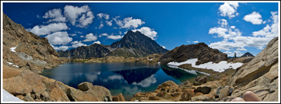
Panorama at Lake Ingalls.

Panorama at Lake Ingalls. Click if you care to embiggen.

Lake Ingalls sits just inside the Alpine Lake Wilderness boundary, in the Teanaway area of Washington State.  In years past, almost all of our hikes ended at an alpine–or, more likely, at that time, sub-alpine lake.  Mason Lake, Lake Valhalla, Rachel Lake, Watson Lakes…  We loved rewarding ourselves with a cool dip or cold plunge and some time spent resting before the return down.  This year, somehow, we’d yet to take a hike with a lake for a reward; the Pacific Ocean doesn’t count.  Lake Ingalls, which sits at an elevation of about 6500’, sounded perfect.

Read more of this post

Nason Ridge, 07/20/08

A Monday commitment meant that we were left searching for a Sunday day hike, and this time Nicole made the call: Nason Ridge, right between US-2 and Lake Wenatchee. Actually, she’s supposed to be writing up this trip report, but it seems we’ll have to settle for some of her comments and impressions on this hike toward the end of this entry. Or look for a separate post from her on this topic. So: based on the trip reports, we expected a moderately difficult hike with no snow, decent views, an alpine lookout, and the high possibility of a mountain goat encounter. We weren’t disappointed.

Like many, we approached Nason Ridge via Round Mountain Trail #1529. Green Trails Map #145 (Wenatchee Lake) shows three ways up to Nason Ridge from US-2, but the route up Round Mountain has the advantage of having the highest starting elevation, at 3900’. The trailhead sits at the end of Road 6910, which is maybe 1/4 mile east of the Nason Creek Rest Area–we knew it was coming, and we still ended up missing it and turning around (look for a driveway with mailboxes and a small 6910 sign) . The road up to the trailhead is in suitable shape for most anyone–we took the Focus this time, and had no problem making it the ~4 miles to the trailhead.

We arrived at the trailhead at 09:55 to find five other cars and an outhouse, which we didn’t use because we’d stopped at the rest area just minutes before. We’d left West Seattle at 07:35, and run into minimal traffic, so that’s a little over two hours of driving time. We stepped out of the car to put on our boots and were immediately greeted by hungry mosquitoes. After applying sunscreen and bug dope, we set off. 10:10.

Read more of this post