Upper Eagle Lake, 10/07/2011-10/08/2011

In lieu of a proper entry (apologies again), I present the contents of my journal and selected photographs:

Eagle Lakes

I-90 -> 970 -> 97 -> US2/97 -> L on WA153N -> L on Gold Creek -> L on 4340 -> L on 4340(300) -> Eagle Lake Trail 431

15:25 – Leave trailhead
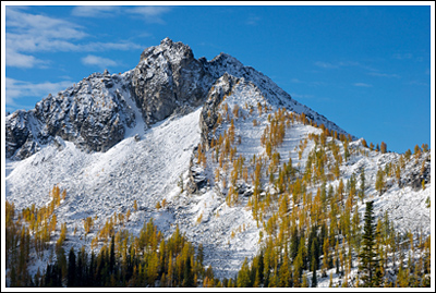
16:20 – Martin Crk int. Larches across valley look awesome! Tired. 2 dayhikers, 1 moto.

2011-10-07_DSC_9093

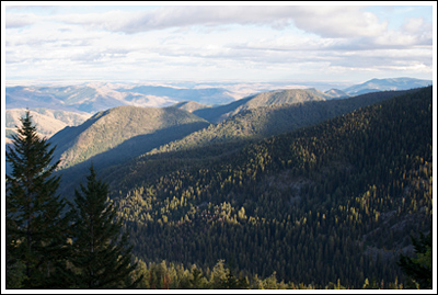
Back down the valley.

2011-10-07_DSC_9096

View across the valley: peaks, snow and larches.

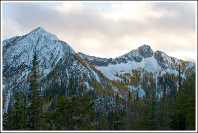
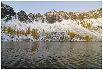
18:30 – Upper Eagle lake — 1-3″ snow; followed footprints. Went upshore and found no campsites (main taken). Ended up in horse camp. Ate beef stroganoff, chocolate, scotch.

10/08

Up at 06:00 — slept poorly; was warm enough, but couldn’t get comfy. Very quiet. Amount of snow makes me worried about loop trip [that I’d planned on].

2011-10-08_DSC_9117

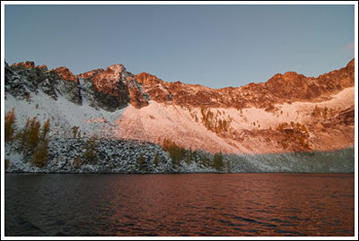
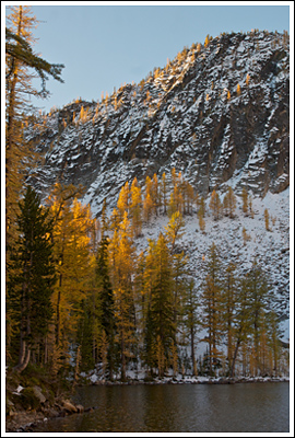
Sunrise at Upper Eagle Lake.
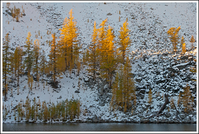
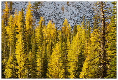
2011-10-08_DSC_9128

Larches.

2011-10-08_DSC_9105

The morning lake.

2011-10-08_DSC_9129

More of the same.

2011-10-08_DSC_9149

Oooh.

2011-10-08_DSC_9169

Heading out; blue skies.

08:45 – Leaving camp; heading home.
10:35 – Martin Crk Int.
11:20 – Car
11:30 – Leave

As is often the case, a few more photos here.

Klapatche Park, 07/24/10-07/25/10

When I first flipped through my copy of 50 Hikes in Mount Rainier National Park and saw Ira Spring’s photograph of Klapatche Park, the destination shot to the top of my to-hike list. And like most locations on my to-hike list, it just stayed there. I was reminded of it again last year, while watching The National Parks: America’s Best Idea, which briefly flashed another Ira Spring photograph of the same location, this one from many years earlier.

The problem is, Klapatche Park isn’t all that easy to get to. In the not-too-distant past, one could park their car within three miles of it, but the road washed out twenty-one years ago and left the western side of The Mountain more isolated than most of the rest.

After walking the more recently decommissioned Carbon River Road earlier this year, I decided that it was time to walk the Westside Road and visit the fabled Klapatche. The weekend’s weather would be perfect, and from what I’d read on the Mt. Rainier National Park website, snow levels seemed pretty favorable, too.

This trip would be solo.

Read more of this post

Carbon River Road and Glacier, 06/12/10-06/13/10

After spending Friday evening celebrating an improbable new job for me, we woke up Saturday morning eager to take advantage of beautiful weather but somewhat unprepared to do so. I’d been thinking about heading to the Carbon River entrance of Mount Rainier National Park, and its nearby location and easy walking made it seem like a good candidate for our first backpack of the year.

The Carbon River washed out the road of the same name some years back, and it stranded what used to be a drive-in campground some five miles down a now-but-perhaps-only-temporarily-decommissioned road. I thought we’d walk the five miles to the campground, set up our tents, and head off and explore the area, perhaps continuing on to Carbon Glacier, the lowest-elevation glacier in the Lower 48.

Nicole on the Carbon River Road.

Even though we didn’t get a super early start, the northwest corner of Mount Rainier National Park is such a quick drive that we’d gotten to the park, stopped in at the ranger station for our permit, and started off down the road by 11:15.

Read more of this post

Gothic Basin, 08/15/09-08/16/09

For various reasons, we hadn’t backpacked in—I just checked—two months!  A fine amount of dayhiking, sure, but what with our upcoming trip to the Canadian Rockies, I felt we needed a bit more conditioning.  And I thought maybe, just maybe, we’d get some clear skies.  After shortening our list earlier in the week to three possible destinations, we decided we’d spend Saturday night in Gothic Basin.

Gothic Basin worked its way onto my must-do list way back when.  As sometimes happens when time passes, details regarding degree of difficulty slipped away from me, replaced only by snapshot statistics: 2600′ elevation gain, ~10 miles round-trip.  No problem.

We were up early enough Saturday morning, and on the road at 05:05.  I felt an early start was important, since we needed to find a campsite.  At 06:55, we pulled onto the side of the road at Barlow Pass, and were walking down the gated road to Monte Cristo ten minutes later.  Low clouds and fog made visibility poor.

Holding...

Holding...

Fifteen minutes after squeezing through the posts on either side of the Monte Cristo gate the road is really closed, and a trail is routed above the washed out road along the South Fork Sauk River.  I’d read that it wasn’t necessary to take the re-route, so we continued along the remains of the road, which wasn’t difficult, but does require that you watch where you step.  We’d be watching each step closely later on, too.

hikers_50

Read more of this post

Big Quilcene to Marmot Pass, 06/06/09-06/07/09

I’d had my eye turned toward the Olympic Peninsula for several weeks. Our only hike on the other side of the Sound was a beach backpack, so we hadn’t really experienced the Olympic Mountains. And, after years of admiring them from afar, it was well past time to do something about it.

Falls in the Big Quilcene River.

Falls in the Big Quilcene River.

Last month, I’d decided that we’d hike the Upper Big Quilcene Trail #833.1 sometime soon. The Forest Service conditions report on 05/18/09 said the trailhead was open and that there was heavy snow around 5000′. With Marmot Pass another 1000′ above that, I decided to wait it out a bit. Several weeks passed, temperatures soared into the 90s—then retreated, and I forgot all about the knee pain from two weeks prior.

hikers_50 Read more of this post