Kalalau Trail, Kauai, 03/13/2013
March 13, 2013 Leave a comment
Hawaii. Islands of my pre-adolescent dreams. After living in Seattle for 10 years, we were lucky enough to be able to go for the first time last February. Adelaide hadn’t yet turned one. And the spoiled little brat got to go back just after turning two. Seriously, it took us thirty-some-odd years to get to Hawaii for the first time, and she’s been there once for every year she’s been on the planet. At least this time her demeanor and behavior had improved to the point where we did a bit more than we could’ve the first time.
The biggest thing on my list was to hike at least a bit of the Kalalau Trail on the Nā Pali Coast. We’d glanced longingly at the trailhead on our first visit to Hawaii, but were content to enjoy Ke’e Beach that time—probably our favorite beach ever so far. Even with a so-so forecast this year, we drove from Poipu to the end of the road (Kuhio Highway 560) and tried our luck.
And we were lucky; the weather was better than we’d hoped for. Helicopter tours continually buzzed overhead. Constantly we soaked in views of the coast ahead and the colorful ocean below. Yes, there were a lot of people. Yes, I wore terrible shoes which blistered my ankles to the point that I have minor scarring. Yes it was only four miles total (two in, two out).
It’s worth it.
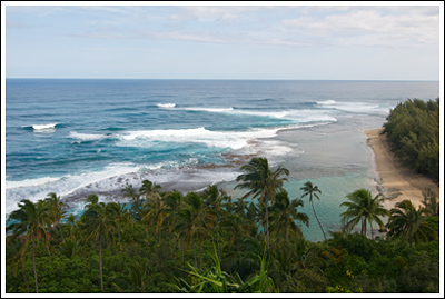
Ke’e beach from above, near the start of the trail.
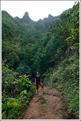
Nicole with valley walls looming above.
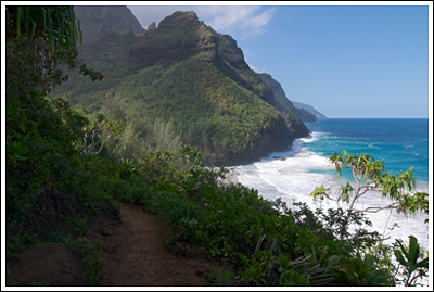
That’s the ticket.
Writing this post has reminded me that I actually did get out on a hike the first time we were in Hawaii. I went with my friend, Casey. I’ll have to write that up, too. (It’s a bit off of the beaten path and takes you out along one of the ridges of the Nā Pali.
The next time we’re back in Hawaii we may try a different island. But Kauai will always be our first. We’ll return, and we’ll backpack this trail, too. I need to camp on the beach here.
Stats: it’s not easy, but it’s not terribly difficult. Don’t drown or fall of cliffs. This is a famous trail so I’m sure you can get more details elsewhere. The Ultimate Kauai Guidebook is a must if you’re planning a trip to the island, whether hiking or not.