Blanca Lake, 07/26/09

We hadn’t yet combined car camping and day hiking this summer, and Cousin Bobby’s number of free weekends before his internship ends can be counted on one finger, so it was decided that we’d head out and camp somewhere Saturday and then hike on Sunday. Blanca Lake has been high on my to-do list for several years—basically since I picked up my first 100 Hikes… book. While researching the hike, I found out that the shorter approach to the trailhead via FS63 (Index-Galena Rd) was inaccessible due to a road closure, but the trailhead was still reachable via FS65 (AKA Beckler River Rd). I thought this might deter some people and keep the trail slightly less busy. So it was decided that we’d head up FS65 seeking a suitable and free camping site and hike up to Blanca Lake the next day.

North Fork Skykomish River near our campsite.

North Fork Skykomish River near our campsite.

Roommate David loaded up the cooler, the back of the Forester was full, and we stopped off in Mill Creek to pick up Cousin Bobby around 09:45 on Saturday morning. After an easy cruise on US-2 through Skykomish, we turned left on Beckler River Rd, which is also a pretty smooth ride, until it first turned to gravel and then intersected with FS63. Along the way there were several choice campsites along the water, but all were taken. Once we turned up FS63, the road became smaller and we were slightly worried we wouldn’t find a nice place to camp. We passed by the trailhead to Blanca lake and came a little closer to the North Fork Skykomish River, eventually finding a decent little grassy campsite with a fire pit and easy access to the water. By noon we were setting up our tents and settling in.

hikers_50

Read more of this post

Summerland & Panhandle Gap, 08/31/08

With late-August weather signaling the end of an already-abbreviated summer, and with the glaring omission of Mt. Rainier National Park (hereafter, MRNP) on our yearly itinerary thus far, we set our sights on Summerland.  Ever since we’d driven along the Sunrise side of Mt. Rainier en route to Mt. Aix earlier this year, we’ve been anxious to return to the area.  Since it was the weekend of Labor Day, we decided to forgo any backpacking plans, opting instead to wake up early in an attempt to beat out our fellow dayhikers.

We were out the door by 05:00 and driving in the dark down a road that I doubted.  Google Maps set me along a different road than I’d taken previously, but we ended up on WA-410 nevertheless.  Clouds hung heavy over the highway, and while I did my best to will them off, windshield wipers were necessary–briefly–on the east side of The Mountain.  I often forget just how close Mt. Rainier is to Seattle–we pulled into the Sunrise/White River entrance at 06:45.  Since it was, as previously stated, the first time this year inside MRNP, we added the $30 annual park pass to our credit card bill (7-day passes are $15, and we know we’ll be coming back more than once in the coming calendar year).   Unfortunately, our success in early arrival meant that no one was manning the entrance booths and instead of a flesh-and-blood annual pass, a machine spit out a receipt that could be exchanged for the real deal.  In the pocket it went, and up the road we drove.

Read more of this post

Mt Si, 08/19/08

After spending ten days with family in Wisconsin, and eating like one might imagine, I came back to Seattle nearly a-pound-per-day heavier and anxious to put the bratwurst behind me.  I decided that I’d take advantage of my Tuesday off and hike something nearby–solo, since Nicole would be working.  With the weather threatening rain and temperatures in the 60s, I wasn’t hiking for views.  After weighing all the factors, I came to the conclusion that if I were ever to hike Mt. Si, it would be now.

The Mt. Si trail is, from what I’ve read, one of the busiest trails known to man.  It’s only ~30 miles from Seattle on I-90, but at 8 miles round-trip with over 3000’ of elevation gain, it ain’t no cakewalk.  This combination keeps the trail consistently populated, with weekends being exceptionally busy.  Plus, it’s the first big piece of rock one sees as they drive up the Snoqualmie Valley–I can’t help but look at it every time by.

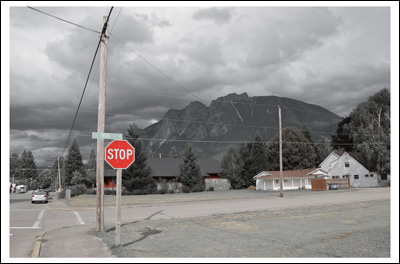
Mt Si from North Bend.

Mt Si from North Bend.

After making each of us a peanut butter and jelly sandwich for our respective (but not respectable) lunches, I left West Seattle at about 10:35 and headed east on I-90.  Take exit 31 to North Bend, and take a right at the downtown stoplight past a place promising Twin Peaks Cherry Pie (North Bend Way).  Shortly after that there’ll be a sign alerting you to the Mount Si Road/432nd SE intersection.  Take a left and follow the road past the Little Si trailhead to the Mount Si trailhead ~2.5 miles down the road.  I pulled into the parking lot about 11:20–about 45 minutes after I’d left West Seattle.  Not bad, but even more exciting was the scene at the parking lot.  I think there were four (4!) other cars parked near the trailhead, with the majority of the vast parking lot completely empty.  Excellent.

Read more of this post