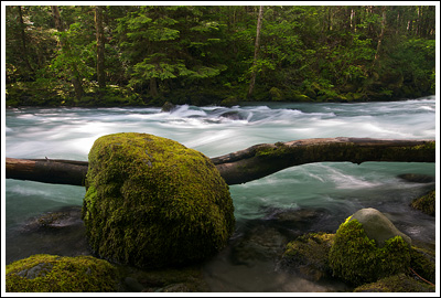
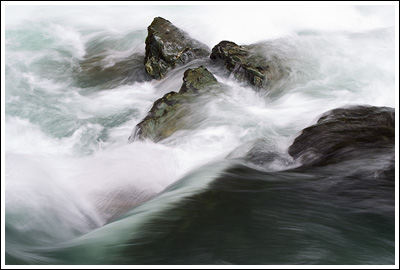
Duckabush River, 06/25/11
June 25, 2011 4 Comments
I spent the better part of a week in June all alone at home, with both Nicole and Adelaide back in Wisconsin, where they remained after the three of us flew out last-minute to visit my Grandpa in the hospital. Evenings were quiet; I vacillated between missing my three-and-a-half-month-old daughter fiercely and reflecting on the time I spent with my Grandpa in my youth and as I grew up and moved away from home.
I did plan, though, on taking advantage of this time alone by doing something. While a backpack sounded good in theory, I knew that I was out of shape, out of practice, and unprepared even as the weekend approached. So I thought a day spent walking along a river would do well for me—I’d stroll along leisurely, set up my tripod liberally, and see how far I got up the Duckabush River before turning around and heading home.
I like driving over to the Olympic Peninsula early in the morning: down through Olympia, up along the Hood Canal with the cruise control set just right until you begin passing through all the small towns with their pickup trucks driven out onto the saltwater flats the tide has revealed.
 By 08:30 I’d left the Subaru parked at the trailhead just off Duckabush Road and started climbing gently into the forest. While the Duckabush River is nearby, for the first two miles, it’s not in sight, and only intermittently audible. At 09:00, I entered The Brothers Wilderness, and the trail began losing the little elevation I’d gained until the river did come into sight at 09:30.
I found a picturesque little spot and set up my tripod, anxious to get in some good shots, since it’d been so long since I’d taken photos of anything other than Adelaide. I spent the next twenty minutes messing about before I continued on…
Shortly thereafter I smelled a campfire at what must be a pleasant little campsite, and then the trail turned away from the river again and began a constant climb. With my tripod stubbornly on my shoulder, I huffed and puffed upward. Yet another instance of me neglecting to eat a proper breakfast in my urge to get on the road. But I’m not blaming it all on lack of energy; there’s a bunch of switchbacks—a bunch more than I’d anticipated. I picked the wrong river to stroll along effortlessly.
After ~thirty minutes, I was rewarded with some pleasant views both across- and down-valley. Reason enough to set up the tripod I’d resisted strapping back to my pack.
But the climb didn’t stop quite there. I continued up, seeing several groups of people here and there, relishing the moments when the unobstructed roar of a waterfall reached my ears. Eventually the trail crested the Big Hump, but there were no views in either direction. And I was only half-happy to begin my descent, knowing I’d have to regain each step on my return.
At 1:45, I reached 5 Mile Camp (apparently 5.3 miles in from where I began). Several backpackers loitered nearby, reluctant, most certainly, to leave such a beautiful spot and head back to civilization. There are several fine spots to set up tents, but it’d be close quarters if a few parties all set up on one night—something I’m sure happens frequently.
I was more than happy to drop my pack and spend ~forty-five minutes climbing on the boulders lining the rushing Duckabush with my tripod in hand, experimenting with various compositions and settings while other hikers arrived and/or left. The water was both colorful and crystal clear, and the sky cooperated by clouding over when I needed it to.
I gathered my things and climbed back up to the main trail, unsure as to whether I’d continue further along the trail or head home. A couple stood there debating the same, and so I was somewhat shamed into continuing on. But only briefly. The slight climb uphill was more than I was willing to invest, and so I stopped as the trail crossed a field of rocks sprouting yellow flowers at 13:00.
Though the flowers were numerous, I was too exhausted to search for a great composition; instead, I documented their existence and put my tripod deep in my backpack before checking out mentally for the day and putting foot in front of foot back up Big Hump and out to the Subaru, which I reached at 15:15.
Were I in better (i.e., acceptable) shape, I probably would’ve enjoyed this one a bit more than I did. But the majority of the hike—in both directions—is a marginally interesting uphill climb, which wasn’t what I envisioned when I set out in the morning. Expectations != Experience. And for that reason, I suppose, this wasn’t a hike I’m raving about here. But make the decision for yourself, because under other circumstances I could’ve loved it.
Stats: ~11 miles round-trip, ~2300’+ elevation gain, 6:45 on the trail, with plenty of that time spent taking photos.


Nice report. A friend or two and myself will be hiking up the NF Skokomish and hopefully out the Duckabush this weekend. Lot of snow in the high country still and a couple potentially hazardous creek crossings.
Thanks, Jay. That sounds like a fun trip. Just looking at Google Maps—how do you get from NF Skokomish over to Duckabush? Near Mt. Hopper at 4600′?
Yep, that pass is called first divide. If you look at the area on acme mapper, you can see the trails and topo for that area. I’m looking forward to it. I’ve hiked around the NF Skok area many times but oddly enough, I have never hiked the Duckabush.
Ah, thanks for the reminder on ACME Mapper. I know I’ve seen it before, but the reminder is nice—it’ll be very useful!
I’ll be looking forward to your trip report!