Carbon River Road and Glacier, 06/12/10-06/13/10
June 17, 2010 Leave a comment
After spending Friday evening celebrating an improbable new job for me, we woke up Saturday morning eager to take advantage of beautiful weather but somewhat unprepared to do so. I’d been thinking about heading to the Carbon River entrance of Mount Rainier National Park, and its nearby location and easy walking made it seem like a good candidate for our first backpack of the year.
The Carbon River washed out the road of the same name some years back, and it stranded what used to be a drive-in campground some five miles down a now-but-perhaps-only-temporarily-decommissioned road. I thought we’d walk the five miles to the campground, set up our tents, and head off and explore the area, perhaps continuing on to Carbon Glacier, the lowest-elevation glacier in the Lower 48.
Even though we didn’t get a super early start, the northwest corner of Mount Rainier National Park is such a quick drive that we’d gotten to the park, stopped in at the ranger station for our permit, and started off down the road by 11:15.

The old growth along the road is impressive. Even though you’re walking a wide road for most of the five miles, it’s very enjoyable. I appreciate the fact that you can no longer cover that distance in fifteen minutes. Though it must’ve been an enjoyable car ride as well—bikes are still allowed, only as far as the campground. We need mountain bikes!
After only a mile or two, a ranger with an ATV stopped alongside us and offered to take our packs up to the campground, as he was headed up that way with a trailer. How could we refuse? Now it truly would be an easy walk to the campground, and we’d have more energy for exploring in the afternoon.
We wandered up the road to the campground, which was very quiet when we arrived around 13:00. There were only a few tents, and there’d remain only a few tents, even though we were there on a Saturday night. We’d seen a decent amount of people heading out, but at camp and during our explorations up to Carbon Glacier, we saw less than ten people. We collected our bags from their hiding place and set up camp. Restrooms and picnic tables made it quite a comfortable backpack.
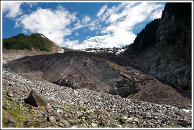
Since it was only early afternoon and we had a decent amount of energy, we decided to hike to the Carbon Glacier viewpoint, ~3.5 miles from the campground. Finally we left the road behind and stayed close to the meandering Carbon River to its source.
I stopped plenty of times for photos, and it took us nearly 3 hours to make it to our turnaround point. Highlights of the hike up were the crossings of the Carbon River and the views of The Mountain up the valley. Of course, at the glacier, clouds moved in and obscured most of Rainier until we turned our backs on her and set off down the trail.
Near that point is the famous Carbon River suspension bridge, and we had to cross it once and cross it twice, just to say we did. It’s bouncy!
By this time we were pretty exhausted, having walked ~9 miles already and being somewhat unpracticed. We concentrated on getting back to camp and tried our best not to run out of water, which we did anyway since I was the only one with a backpack for the hike from camp up to the glacier.
At the end of our 12-mile day we quickly ate, drank, and struggled getting our bag up on the bear poles before we retreated to the tent and dozed off early. I didn’t even see the stars!

Sunday morning we woke up, broke down camp, and headed out. This time there wasn’t a ranger to take our packs down the road for us. On our way out we took the small spur trail over the Carbon River to Chenuis Falls, which was beautiful and had a great swimming hole at the bottom.
Sometime around 11:00 we were back at the Subaru.
We really loved this area. It’s a great place to get out quickly, and there’s a lot of beauty! The easy grade and comfortable camps make this a great place to get out with newbies, families, etc. We definitely plan on going back with more time, exploring other areas and/or relaxing.
Stats for the two days: ~18 miles, ~1500’+ gain, lots of log bridges.
As always, a few more photos on Flickr.


